There are a lot of "big" rivers in this Country but I am referring to two of the largest, the Mississippi and Ohio. Native Americans called the Mississippi the Father of the Waters and Ohio was from an Iroquois word meaning "Great River".
We left Portage Des Sioux just after a flood and while the waters had receded and most of the floating debris had run off we still needed to be alert. As you can see from this shot taken as we were entering Mel Price Lock at Alton, Illinois not all of the "junk" was gone. Actually it had sort of "coalesced" here where the water is slack above the lock. We try to shift out of gear so that the props are not spinning and sort of glide through the logs before we re-engage the props.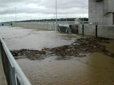
Our traveling companions "Mojo" and "Telegraph Hill" exiting Mel Price Lock. Bill & Donna on "Telegraph Hill" are friends from Sioux Harbor who have decided to travel down with us.

Our traveling companions "Mojo" and "Telegraph Hill" exiting Mel Price Lock. Bill & Donna on "Telegraph Hill" are friends from Sioux Harbor who have decided to travel down with us.

The waves on the water between the bow of "Lauren Grace" and the island in the distance are caused by the flow of the Missouri River into the Mississippi. This is the confluence of the "Big Muddy", as the Missouri is called, and Mississippi. The water color is usually markedly different but not so much today due to the recent flooding. The current really picks up from this point due to the fast current of the free flowing Missouri and that is why you see the waves.

This canal leads the way to the final lock on the Mississippi. Occasionally boats miss this sign and follow the old riverbed, which leads them to a treacherous rocky area. In fairness to the boaters I must say that the charts are not clear at this junction, but the sign is large. Once through Lock 27 and out of the canal the Mississippi is open river with no controlling dams all the way to New Orleans.

Only a few miles downstream from Lock 27 is the city of St. Louis. The large stern wheeler in the foreground is the "American Queen" the biggest stern wheeler ever built; she was launched in 1995 when she joined the "Delta Queen" and the "Mississippi Queen" plying the rivers and carrying passengers wanting to re-live the luxury days of riverboat travel. Many times we have seen these boats on the waters, at night they sparkle like crystal palaces and when they go through a lock they give a steam calliope concert. This was the custom when a riverboat called at a town back in the day, if we are near the lock we always hang out to hear the concert. In recent years river travel has fallen on hard times and the boats were sold several times. The "Delta Queen" has likely taken her last voyage but the fate of the much newer American and Mississippi Queens is unknown.

A bit of the St. Louis skyline

The old PET Incorporated headquarters building. Larry worked here for many years before PET was acquired by another company and the headquarters closed. The sign on the top says "Apartments for Lease"

The structure with the arches in the foreground is part of the supports for famous Eads Bridge, an engineering marvel in its day. Completed in 1874 the bridge was innovative for a number of reasons, not the least of which is it was the first bridge to use steel as a primary structural material. The cassions used to provide a water tight space to pour the piers remain among the deepest ever sunk.

The gleaming Gateway Arch framing the historic Old Courthouse

The "Arch" as locals call it, designed by Eero Saarinen, was the winning design for a monument to symbolize St. Louis' role as the Gateway to the West . The competition was initiated shortly after WWII to solicit designs for a monument to be built on the grounds of the Jefferson National Expansion Memorial National Historic Site (now you know why they just say "the Arch") which was established in 1935 by President Roosevelt to memorialize Thomas Jefferson's role in the territorial expansion of our Nation.
Construction on the 630' tall by 630' wide monument, the largest in the Country, was begun in 1959 and completed in 1965. It was built from both sides and the last piece was the "key" that joined the two legs

Just downstream from the arch a few miles is Jefferson Barracks National Cemetery which overlooks the Mississippi and is barely visible through the trees
Just downstream from the arch a few miles is Jefferson Barracks National Cemetery which overlooks the Mississippi and is barely visible through the trees

We pass under the JB (Jefferson Barracks) Bridge and St. Louis is behind us.

I mentioned that the current really picked up at the confluence with the Missouri and that we are below the last controlling dam on the Mississippi and that we are going down stream following the tail end of a flood. All of these factors made our travel on the Mississippi below somewhat challenging.
The current was unusually fast, the marks (buoys) were often missing or unreliable because they had been moved out of place, and there was still some debris in the water. This next series of photos shows one of the hazards that boaters traveling at that time started calling "diving buoys". These shots were taken in a 30 second span of time so you can see that we had to be constantly alert.
In this shot you see no buoys, just "funny" riffles on the water.

Here we are a bit closer to the "riffles"

Then we see the reason for those "riffles", steel buoys riding just below the surface are popping up.

Now they are rising higher out of the water

In a flash they start diving back down as pressure against them intensifies.

There you saw it, now you don't!. Remember this entire sequence happened in only 30 seconds.

Let me explain that buoys are anchored into the river bottom and a cable is attached between the anchor and the buoy, the cable has a finite length which is designed to allow for the appropriate water depth plus a little extra. During the flooding the current below St. Louis was running at probably something close to 9 mph; if a 60 ft long tree being pushed by 9 mph current snags a buoy it moves. Now it is in the wrong place or maybe it becomes hung up on something underwater further down the line after the original tree is long gone. When the buoy (and its anchor) is in water too deep or has something underwater pushing against the cable it is submerged, but because it is buoyant it struggles to rise to the surface when the pressure against the cable is slacked even a little. The current alone provides a lot of pressure and if the current is pushing a tree limb or other submerged item it can make the buoy dive underwater and then struggle to resurface. We watch for unusual disturbance on the surface and try to give anything that looks "funny" a wide berth. We were lucky, some others were not and incurred damage to their props and shafts from some of these buoys.
The confluence of the Ohio and Mississippi. You can see the incredible difference in the water color here, the Mississippi water is the brown color. At the far right in the photo is the bow of a barge just shoving out of the Ohio and into the Mississippi. Today the Ohio was placid and her 2 knot or so of current (on our nose) was a welcome relief after the previous couple of days.

Another confluence, this is where the Cumberland flows into the Ohio.

Following a tow as we turn up the Cumberland River