Wednesday, November 12, 2008

Down the Big Rivers

There are a lot of "big" rivers in this Country but I am referring to two of the largest, the Mississippi and Ohio. Native Americans called the Mississippi the Father of the Waters and Ohio was from an Iroquois word meaning "Great River".


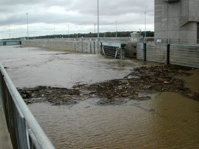
We left Portage Des Sioux just after a flood and while the waters had receded and most of the floating debris had run off we still needed to be alert. As you can see from this shot taken as we were entering Mel Price Lock at Alton, Illinois not all of the "junk" was gone. Actually it had sort of "coalesced" here where the water is slack above the lock. We try to shift out of gear so that the props are not spinning and sort of glide through the logs before we re-engage the props.
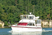
Our traveling companions "Mojo" and "Telegraph Hill" exiting Mel Price Lock. Bill & Donna on "Telegraph Hill" are friends from Sioux Harbor who have decided to travel down with us.


The waves on the water between the bow of "Lauren Grace" and the island in the distance are caused by the flow of the Missouri River into the Mississippi. This is the confluence of the "Big Muddy", as the Missouri is called, and Mississippi. The water color is usually markedly different but not so much today due to the recent flooding. The current really picks up from this point due to the fast current of the free flowing Missouri and that is why you see the waves.


This canal leads the way to the final lock on the Mississippi. Occasionally boats miss this sign and follow the old riverbed, which leads them to a treacherous rocky area. In fairness to the boaters I must say that the charts are not clear at this junction, but the sign is large. Once through Lock 27 and out of the canal the Mississippi is open river with no controlling dams all the way to New Orleans.


Only a few miles downstream from Lock 27 is the city of St. Louis. The large stern wheeler in the foreground is the "American Queen" the biggest stern wheeler ever built; she was launched in 1995 when she joined the "Delta Queen" and the "Mississippi Queen" plying the rivers and carrying passengers wanting to re-live the luxury days of riverboat travel. Many times we have seen these boats on the waters, at night they sparkle like crystal palaces and when they go through a lock they give a steam calliope concert. This was the custom when a riverboat called at a town back in the day, if we are near the lock we always hang out to hear the concert. In recent years river travel has fallen on hard times and the boats were sold several times. The "Delta Queen" has likely taken her last voyage but the fate of the much newer American and Mississippi Queens is unknown.


A bit of the St. Louis skyline


The old PET Incorporated headquarters building. Larry worked here for many years before PET was acquired by another company and the headquarters closed. The sign on the top says "Apartments for Lease"


The structure with the arches in the foreground is part of the supports for famous Eads Bridge, an engineering marvel in its day. Completed in 1874 the bridge was innovative for a number of reasons, not the least of which is it was the first bridge to use steel as a primary structural material. The cassions used to provide a water tight space to pour the piers remain among the deepest ever sunk.


The gleaming Gateway Arch framing the historic Old Courthouse


The "Arch" as locals call it, designed by Eero Saarinen, was the winning design for a monument to symbolize St. Louis' role as the Gateway to the West . The competition was initiated shortly after WWII to solicit designs for a monument to be built on the grounds of the Jefferson National Expansion Memorial National Historic Site (now you know why they just say "the Arch") which was established in 1935 by President Roosevelt to memorialize Thomas Jefferson's role in the territorial expansion of our Nation.


Construction on the 630' tall by 630' wide monument, the largest in the Country, was begun in 1959 and completed in 1965. It was built from both sides and the last piece was the "key" that joined the two legs

Just downstream from the arch a few miles is Jefferson Barracks National Cemetery which overlooks the Mississippi and is barely visible through the trees


We pass under the JB (Jefferson Barracks) Bridge and St. Louis is behind us.


I mentioned that the current really picked up at the confluence with the Missouri and that we are below the last controlling dam on the Mississippi and that we are going down stream following the tail end of a flood. All of these factors made our travel on the Mississippi below somewhat challenging.


The current was unusually fast, the marks (buoys) were often missing or unreliable because they had been moved out of place, and there was still some debris in the water. This next series of photos shows one of the hazards that boaters traveling at that time started calling "diving buoys". These shots were taken in a 30 second span of time so you can see that we had to be constantly alert.


In this shot you see no buoys, just "funny" riffles on the water.


Here we are a bit closer to the "riffles"


Then we see the reason for those "riffles", steel buoys riding just below the surface are popping up.


Now they are rising higher out of the water


In a flash they start diving back down as pressure against them intensifies.


There you saw it, now you don't!. Remember this entire sequence happened in only 30 seconds.


Let me explain that buoys are anchored into the river bottom and a cable is attached between the anchor and the buoy, the cable has a finite length which is designed to allow for the appropriate water depth plus a little extra. During the flooding the current below St. Louis was running at probably something close to 9 mph; if a 60 ft long tree being pushed by 9 mph current snags a buoy it moves. Now it is in the wrong place or maybe it becomes hung up on something underwater further down the line after the original tree is long gone. When the buoy (and its anchor) is in water too deep or has something underwater pushing against the cable it is submerged, but because it is buoyant it struggles to rise to the surface when the pressure against the cable is slacked even a little. The current alone provides a lot of pressure and if the current is pushing a tree limb or other submerged item it can make the buoy dive underwater and then struggle to resurface. We watch for unusual disturbance on the surface and try to give anything that looks "funny" a wide berth. We were lucky, some others were not and incurred damage to their props and shafts from some of these buoys.


The confluence of the Ohio and Mississippi. You can see the incredible difference in the water color here, the Mississippi water is the brown color. At the far right in the photo is the bow of a barge just shoving out of the Ohio and into the Mississippi. Today the Ohio was placid and her 2 knot or so of current (on our nose) was a welcome relief after the previous couple of days.


Another confluence, this is where the Cumberland flows into the Ohio.


Following a tow as we turn up the Cumberland River


Alton Pool Where it all began

We arrived "home" in Alton Pool on Labor Day weekend. It felt really good to be back in those familiar waters. This really is where it all began back in the early 1980s (neither of us can remember the exact year but we are positive it was between '80 and '82) when we got our first boat, a little 22' Southcoast sailboat. We rented a slip in a marina at Portage Des Sioux and made friends with all the local sailors there.
It was within that helpful group of friends, sharing their love of boating with us and teaching us, that our love of the water and of quiet anchorages developed. Even though Alton Pool is less than 20 miles, as the crow flies, from the city of St. Louis it is a world apart in character. Here the scenery is natural, the stars bright and the wildlife abundant.
Twenty years ago there were few fancy marinas catering to transient boaters so our group outings included quiet anchorages. You might find it amusing that the first time we anchored overnight I didn't sleep a wink because I was certain that at least one of two horrible possibilities would beset us; #1 our anchor would not hold and the current would carry us downstream 14 miles to the dam where we would smash and perish, or #2 we would sink and drown.
My friend had told me that I could use a tree on the island as a reference and anytime during the night if I looked out and could see the tree I would know I was still safely secured. I spent the night lying on a settee in the "salon" (and I use the term loosely because, did I mention this was a 22' boat) with one foot on the floor waiting for water to come in and let me know we were sinking. Every 15 minutes or so I popped up to look out the window and check if the tree was still there. It was a long night! Larry slept like a baby, I guess he figured that one of us worrying was enough! This is ancient history but I share it so that you will understand that you don't have to be born with water in your veins to love boating; boaters are among the friendliest and most helpful people on the planet.

Entering the channel to Sioux Harbor, our "home" marina, where they had a slip waiting for us.


"Our Lady of the Rivers" Shrine was erected by a grateful community to honor the Virgin Mary after the tiny town of Portage des Sioux, MO was threatened by, and ultimately spared from the devastating flood of 1951. In only a few years the local Parish raised the funds for this 25' fiberglass statue that is set on a 20' concrete pedestal. The Shrine was dedicated in 1957 and has stood firm through many devastating floods. At the crest of the flood of 1993 (the worst one so far) only the head was above water. The current was fast, perhaps 6 mph,and debris as large as small sheds was floating down the river; when the waters receded the "Statue" was firmly in place and only clean up and electrical repairs were needed. Every summer boats from the area parade past the Statue for the annual Blessing of the Fleet.

The beautiful bluffs that stand on the Illinois side of the Mississippi in Alton Pool. Below the bluffs the Great River Road (a National Scenic Byway) runs along the water.


We remained for a month here while we visited with friends & family, traveled to Boise and caught up with Doctors & Dentists. And just so we would not forget the challenges of boating on the Mississippi there was even a flood while we were there.


Wednesday, October 29, 2008

CHICAGO, CHICAGO !! ...Another Excellent Adventure

We have visited Chicago more times than I can count. I had family in the city when I was a kid and Larry traveled there for work off and on for years. When you live in St. Louis it makes a nice weekend get-away; but approaching it from the Lake Michigan side was fun and really special. Our trip across the 60 miles or so of open lake from St. Joe Michigan was a good ride; you will notice that the skyline looks hazy and it was but that soon blew out.
We took a mooring ball at Monroe Harbor during our time there. This put us right in the heart of everything, only a couple of blocks from the Art Institute and Millennium Park. About a mile to Navy Pier which you can see in the shots below.

The wall like structure you see in the foreground here is the seawall that protects the mooring basin from the open waters of Lake Michigan

Another shot of Navy Pier with the giant Ferris Wheel . Did you know that the first Ferris Wheel, invented by a Mr. Ferris was introduced at the Chicago World's Fair in 1893.

Daytime and nighttime views from our mooring with the Sears Tower dwarfing everything else.


The bright white light in the left quarter of this shot is the "castle" on the top of White Castle headquarters building. A moving platform (boat) is not the best for night photography!


Sorry about having duplicate shots here but I am not yet clever enough to eliminate the duplicate after I have mistakenly uploaded it to the blog twice, just bear with me. Anyway this is another view from our "sun room".


In the picture below the building in the foreground with the tall lightening rod is the Prudential Building, believe it or not when I was young it was the tallest building in the City, now it is dwarfed by newer towers. I really thought I was big stuff back in the 60's when I won a National 4-H award and was treated to dinner in the club at the top of the Prudential Building.


One of the major highlights of the entire voyage was our travel through the heart of Chicago. We have just passed through the Chicago Lock (that was build to keep water from the Chicago River from flowing into Lake Michigan) and are about to pass under famous Lake Shore Drive. Chicagoans (and all of us) can thank Daniel Burnham the visionary architect of the Chicago World's Fair and a pioneer in urban planning for the beautiful green ribbon along the lakefront and Lake Shore Drive.
These bridges no longer open for boat traffic (they did when I was a kid) and we had to lower our radar in order to be low enough to pass under some of them. What a thrill passing under all the busy traffic of the city as we continued on our way. You can see from this photo that there are a lot of bridges.


More fabulous views! If you visit Chicago you can experience some of this by taking the Architectural Tour that leaves from Navy Pier, it is really worth it to see the city from this perspective.


Flower baskets line areas along the river, which is really a canal at this point


The beautiful Wrigley Building on Michigan Avenue


And the Michigan Avenue bridge! It's the only one that we noticed with flags.


State Street the home of Marshall Field's, well once upon a time.


On some of those bridges we didn't have very much clearance as you can see. That white area in the foreground is the top of "Lauren Grace". Yikes!


Expensive condo buildings with private docks.


Some of the bridge structures were beautiful, these tower like structures are where the bridge tender operated from back in the day when the actually "tended" the bridges.


Oops! Now we get to the not so nice part of the city. The business district and condos are behind us and the stinky industrial area is there for us to see too. Here they were making cars into "cubes", later they will be loaded onto barges for a trip to somewhere.


Stinky part and all it was still a great ride that gave us a spectacular perspective on Chicago. We loved it!


Tuesday, October 28, 2008

A Few Facts About Michigan Dunes & Forests

We enjoyed our visit to a museum in Grand Haven and learned, or perhaps were reminded of, some facts about the formation of the Great Lakes.

The Great Lakes were formed over hundreds of thousands of years by the advance and retreat of giant glaciers. Up to a mile high in some places the ice moved south from the Arctic, scouring the earth as it passed. Advancing at an average rate of a few thousand feet per year this conglomeration of ice, rock and soil took some 4,000 years to stretch from the Arctic Circle to Lake Michigan. As the glaciers spread they deepened existing valleys, the largest of which eventually formed the Great Lakes
Over a span of about a million years the glaciers underwent four major advances and retreats. As they melted and moved back north they left enormous deposits of all they had dragged south with them. Huge heaps of gravel and sand remained after the last retreat some 12,000 years ago. These deposits now serve as one of Michigan's most important natural resources.
This is especially apparent in West Michigan where they are blessed with very unique terrain at the water's edge. Wind & storms exposed the sand, allowing it to drift toward shore and creating the dune structure in the region. These are the largest freshwater dunes in the world.

Who knew that Michigan trees provided the lumber to rebuild Chicago after the Great Fire of 1871?! Actually I never even thought about it before but this is what we learned:

Starting from a few small-scale logging operations in the early 1830's Michigan became the #1 lumber producing state in the country by 1880. Primarily the lumber was eastern white pine which was preferred because it was soft, and easy to work with. Michigan's trees provided the lumber to replace homes and structures lost in the Great Chicago Fire of 1871 and to build houses throughout the Midwest. By 1900 Michigan forests were logged out.

Monday, October 27, 2008

GLORIOUS GRAND HAVEN

We really enjoyed our time in Grand Haven, like many or perhaps I should say most of the towns along the Michigan shoreline it in approached through a canal that is marked by a lighthouse. In this case the canal leads right into the Grand River and carries quite a lot of traffic, some of it commercial boat traffic.


The city marina is right along the canal wall and beyond the wall is a park and "main street". It proved to be a great spot to meet the local folks as well as the local boaters. Jim from "Blue Angel", a Grand Haven native, came by and introduced himself and offered to take us to the grocery store.

You might wonder if he just spends all his time walking the docks and introducing himself but that is not how it happens. Being "cruisers" themselves the Angels know that in August cruising boats will start making our way down the Lake. We belong to an organization of boaters cruising the Loop" (the AGLCA, America's Great Loop Cruisers Association) and being a member of the AGLCA entitles us to fly a little flag known as a burgee. Other boaters recognize the burgee and that is an easy way to meet others having a similar plan or interest, generally conversation flows easily from there. Boaters are generally always willing to lend a hand to others and cruisers, especially, know what you really need which is usually a way to get fresh provisions.

Here you see the Grand Haven Canal with the lighthouse in the background
Grand Haven is known as Coast Guard City USA. This stems from the time of the arrival of the Coast Guard Cutter "Escanaba" which was home ported in Grand Haven from 1932 until it was called to duty in WWII, and subsequently sunk by a German U Boat. The citizens of Grand haven organized a war bond campaign and raised over a million dollars in only three months to pay for a second Escanaba. Every August Grand Haven hosts the Coast Guard Festival. I believe I mentioned that there is some commercial traffic on the Grand River. Here you see an ore freighter backing down the river! No tug boat is hidden on the other side guiding or pushing, he is operating under his own power. This shot is not cropped up, and those small boats you see are really quite close to the freighter. This is late on a Sunday morning and there is a lot of small boat activity.
Notice the green buoys in the background, he is turning a corner as he heads from the river to the canal. We actually saw the freighter arrive the previous evening just before dark. He is so large that he is unable to turn around in the river and must exit back to the Lake by backing down the river!
The little piece of stainless steel hand rail and the rope that you see in the left foreground is the stern of "Lauren Grace"


Beautiful Charlevoix Michigan

Another spectacular sunset on Lake Michigan.
The Charlevoix Lighthouse marks the entry into the canal leading to Round Lake which then leads mariners to Lake Charlevoix. Visitors and residents stroll along the canal to enjoy the sunset.


"Fairy Houses" in lovely Charlevoix

Also called "Mushroom" houses these were designed as residences by Earl Young who often sketched the concept that he visualized and left the detailed "working drawings" for his wife to complete. Each home share a common element of whimsy in the irregular shapes, and the curvy roofs. The first of these houses was built in 1918 and there are about 30 of them in Charlevoix. Young was a great promoter of the area as a summer resort.


Young had what I suppose you might call a vision for each project. He tried to fit each home to the site that it was to be built on and he specified mostly natural building materials. He was creative in utilizing the site


The "icing" on the chimney is a recurring theme in Young's designs